Park Agility Parking Guidance

Smart City Planning – Combining Wayfinding Signage with Parking Technology at the Precinct Level

Precinct level parking solutions are increasingly becoming an integral part of smart city planning.

With clusters of parking options in busy city centre or shopping and entertainment precincts, managing traffic flow at key ‘last mile’ decision points is critical to the reduction of congestion.

Whether parking facilities are utilising area count or per-bay parking guidance solutions, data collected from various sensors and sites can be consolidated and analysed in real time.

The advantage of incorporating precinct level wayfinding signage is that data from multiple parking assets, both council and commercially operated; on-and off-street; can be combined and displayed to drivers. In doing so, the driving public are delivered the benefit of real-time parking availability information in the last few minutes of their journey. This helps each individual to make informed decisions about which direction to turn and with the further community benefit of helping to alleviate traffic congestion during peak periods.

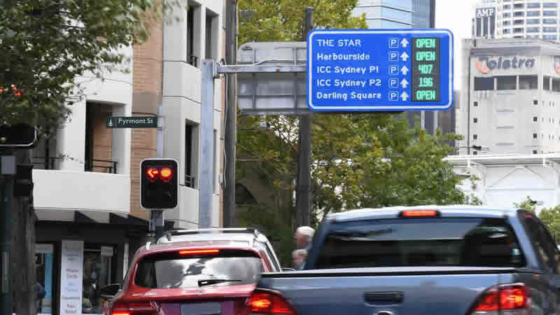
Consider Sydney’s ICC Darling Harbour precinct, home to a convention centre, a casino, multiple hotels and restaurants, a shopping area and various tourist attractions. In addition, it hosts public events and celebrations throughout the year. Utilising a precinct level solution that pulls parking availability data from several separate parking facilities, the highly visible parking wayfinding signs are located above two major access roads, allowing drivers to decide which direction to head according to parking availability. Not only does this assist traffic flow during busy periods, but it also contributes to an improved visitor experience

Consider Sydney’s ICC Darling Harbour precinct, home to a convention centre, a casino, multiple hotels and restaurants, a shopping area and various tourist attractions. In addition, it hosts public events and celebrations throughout the year. Utilising a precinct level solution that pulls parking availability data from several separate parking facilities, the highly visible parking wayfinding signs are located above two major access roads, allowing drivers to decide which direction to head according to parking availability. Not only does this assist traffic flow during busy periods, but it also contributes to an improved visitor experience

Similarly, local councils across the country such as: City of Darwin, Waverley in Sydney’s east, City of Launceston, Bayside in Melbourne’s south and several others are turning to smart, precinct level solutions that direct drivers to parking facilities that are within walking distance of main shopping thoroughfares, beaches and eateries. This use of technology ensures a quality experience for locals and visitors alike and assists in the reduction of congestion and CO2 emissions, lowering car park complaints and incident reports.

By utilising cloud-based, wireless and solar technologies, precinct level parking solutions are a smart, green solution for cities that is also dependable, accurate and extendible for future needs.

Related Articles
Park Agility Parking Guidance
X

    Contact Us

    Australia: +61 (0)2 8488 3333
    Europe: +41 (0)21 805 05 90
    or
    leave a message below and one of our Park Agility team will be in touch.